Back ناريف Arabic نهر ناريف ARZ नारेउ AWA ناریف چایی AZB Нараў Byelorussian Нараў BE-X-OLD Нарев Bulgarian Narew BS Narev CEB Narew Czech
| Narew Нараў, Нарев, Narevas | |
|---|---|
 Braided channels of the Narew at Strękowa Góra. | |
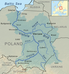
 Narew as part of the Vistula watershed. | |
| Location | |
| Country | Poland, Belarus |
| Voivodeships / Voblasts | Grodno, Podlaskie, Mazovian |
| Physical characteristics | |
| Source | |
| • location | north-eastern part of the Białowieża Forest near Dzikie Bagno, Belarus |
| • coordinates | 52°52′24.68″N 24°13′8.87″E / 52.8735222°N 24.2191306°E |
| • elevation | 159 m (522 ft) |
| Mouth | Vistula |
• location | Modlin (Nowy Dwór Mazowiecki), Poland |
• coordinates | 52°26′01″N 20°40′33″E / 52.4335°N 20.6759°E |
• elevation | 70.7 m (232 ft) |
| Length | 499 km (310 mi) |
| Basin size | 74,527 km2 (28,775 sq mi) |
| Discharge | |
| • location | mouth |
| • average | 313 m3/s (11,100 cu ft/s) |
| Discharge | |
| • location | entering Pułtusk |
| • average | 146 m3/s (5,200 cu ft/s) |
| Basin features | |
| Progression | Vistula→ Baltic Sea |
The Narew ([ˈnarɛf]; Belarusian: Нараў, romanized: Naraŭ; Lithuanian: Narevas or Naruva) is a 499-kilometre (310 mi) river primarily in north-eastern Poland. It is a tributary of the river Vistula. The Narew is one of Europe's few braided rivers, the term relating to the twisted channels resembling braided hair. Around 57 kilometres (35 mi) of the river flows through western Belarus.
© MMXXIII Rich X Search. We shall prevail. All rights reserved. Rich X Search